1961 Map of Oregon City
USGS Topo · Published 1963About this map
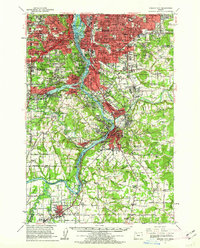
The Willamette River and Clackamas River define the industrial and residential corridors of this region in the early 1960s. Oregon City sits as a primary hub, showing the historic Canemah district and the Mountain View Cem overlooking the river bends. To the north, the expanding suburbs of Portland reach through Arleta, Woodstock, and Milwaukie, while the Southern Pacific and Portland Traction Co rail lines track the water routes. The landscape transitions from the dense urban grid of Brooklyn to the large military installation at Camp Withycombe. Significant local infrastructure is noted throughout, including the McLoughlin Substation and various radio facilities such as Radio Facility (KEX). Farther south, the rural character remains evident in settlements like New Era and Central Point, where the Tualatin River meets the Willamette near Lake Oswego.
Find a feature on this map
211 named features on this map. Tap any name to fly to it.
Don’t see what you’re looking for? This feature index may not catch every label — zoom into the map to look around manually.
Map Details
Editions of this 1961 Oregon City Map
This is the sole edition of this map. No revisions or reprints were ever made.
Other maps of this area

1897 · Portland
USGS Topo · 1:62,500

1905 · Portland
USGS Topo · 1:62,500

1911 · Boring
USGS Topo · 1:48,000

1914 · Boring
USGS Topo · 1:62,500

1914 · Oregon City
USGS Topo · 1:62,500

1915 · Hillsboro
USGS Topo · 1:62,500

1916 · Tualatin
USGS Topo · 1:62,500

1916 · Estacada
USGS Topo · 1:125,000

1918 · Hillsboro
USGS Topo · 1:62,500

1918 · Troutdale
USGS Topo · 1:62,500