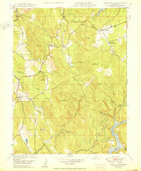
1950 Map of Oregon House
USGS Topo · Published 1950About this map
Oregon House serves as the primary settlement hub in this post-war survey of Yuba County, situated amidst a landscape defined by ranching and timber. Local landmarks such as the Oregon House School and a nearby sawmill reflect the community's early infrastructure and reliance on natural resources. The terrain is marked by significant hydraulic and agricultural features, including the Los Verjeles Dam at Lake Mildred and a network of siphons and flumes that suggest a sophisticated approach to water management for local ranches like Virginia Ranch and Pal O Mine Ranch. To the southeast, the Englebright Reservoir on the Yuba River dominates the drainage system, while numerous named peaks like Stanfield Hill and Daugherty Hill segment the various creek basins including Willow Glen Creek and Dry Creek.
Find a feature on this map
37 named features on this map. Tap any name to fly to it.
Don’t see what you’re looking for? This feature index may not catch every label — zoom into the map to look around manually.
Map Details
Editions of this 1950 Oregon House Map
This is the sole edition of this map. No revisions or reprints were ever made.
Other maps of this area

1888 · Smartsville
USGS Topo · 1:125,000

1891 · Smartsville
USGS Topo · 1:125,000

1892 · Smartsville
USGS Topo · 1:125,000

1894 · Smartsville
USGS Topo · 1:125,000

1895 · Smartsville
USGS Topo · 1:125,000

1911 · Browns Valley
USGS Topo · 1:31,680
1912 · Prairie Creek
USGS Topo · 1:31,680

1941 · Bangor
USGS Topo · 1:62,500

1944 · Bangor
USGS Topo · 1:62,500
1947 · Loma Rica
USGS Topo · 1:24,000