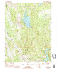
1995 Map of Oregon House
USGS Topo · Published 1995About this map
Oregon House sits at the northern end of this mid-1990s survey, serving as a focal point for a region defined by its water management and ranching legacy. The landscape is dominated by the reservoir of Collins Lake, held by the Virginia Ranch Dam, and the winding course of the Yuba River to the south. Along the river, the Harry L Englebright Lake spans the boundary between Yuba County and Nevada County.
Find a feature on this map
38 named features on this map. Tap any name to fly to it.
Don’t see what you’re looking for? This feature index may not catch every label — zoom into the map to look around manually.
Map Details
Editions of this 1995 Oregon House Map
This is the sole edition of this map. No revisions or reprints were ever made.
Other maps of this area

1888 · Smartsville
USGS Topo · 1:125,000

1891 · Smartsville
USGS Topo · 1:125,000

1892 · Smartsville
USGS Topo · 1:125,000

1894 · Smartsville
USGS Topo · 1:125,000

1895 · Smartsville
USGS Topo · 1:125,000

1911 · Browns Valley
USGS Topo · 1:31,680
1912 · Prairie Creek
USGS Topo · 1:31,680

1941 · Bangor
USGS Topo · 1:62,500

1944 · Bangor
USGS Topo · 1:62,500
1947 · Loma Rica
USGS Topo · 1:24,000