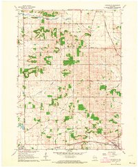
1962 Map of Orfordville
USGS Topo · Published 1964About this map
The village of Orfordville serves as the eastern anchor of this Rock County landscape, situated at the intersection of critical rail corridors during the early 1960s. The southern boundary of the map features the Chicago Milwaukee St Paul and Pacific railroad passing through the edge of Brodhead, while the Chicago and North Western line cuts through the northeast near the small settlement of Cainville. This area is characterized by its agricultural network and early rural community centers, including Magnolia and several established burial grounds like Calvary Cem and West Magnolia Cem.
Find a feature on this map
24 named features on this map. Tap any name to fly to it.
Don’t see what you’re looking for? This feature index may not catch every label — zoom into the map to look around manually.
Map Details
Editions of this 1962 Orfordville Map
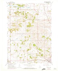
2 editions found
Other maps of this area

1889 · Evansville
USGS Topo · 1:62,500

1890 · Stoughton
USGS Topo · 1:62,500

1891 · Janesville
USGS Topo · 1:62,500

1893 · Janesville
USGS Topo · 1:62,500

1893 · Brodhead
USGS Topo · 1:62,500

1894 · Evansville
USGS Topo · 1:62,500

1906 · Evansville
USGS Topo · 1:62,500

1954 · Rockford
USGS Topo · 1:250,000

1955 · Rockford
USGS Topo · 1:250,000

1958 · Rockford
USGS Topo · 1:250,000