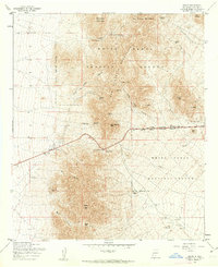
1955 Map of Organ
USGS Topo · Published 1962About this map
Organ sits at the base of the San Augustin Mountains, serving as a focal point for this mid-century survey of the high desert. The map captures a landscape defined by its mining heritage and its transition into a military testing site. Prospectors and local historians can trace industrial activity at the Empire Zinc Mine, Silver King Mine, and Black Prince Mine, which are scattered throughout the rugged slopes and canyons.
Find a feature on this map
45 named features on this map. Tap any name to fly to it.
Don’t see what you’re looking for? This feature index may not catch every label — zoom into the map to look around manually.
Map Details
Editions of this 1955 Organ Map
4 editions found
Other maps of this area

1891 · Las Cruces
USGS Topo · 1:125,000

1893 · Las Cruces
USGS Topo · 1:125,000

1916 · Tonuco
USGS Topo · 1:125,000

1916 · Point Of Sands
USGS Topo · 1:125,000

1932 · Tonuco
USGS Topo · 1:125,000

1941 · Organ Peak
USGS Topo · 1:62,500

1943 · Parker Lake
USGS Topo · 1:62,500

1943 · Organ Peak
USGS Topo · 1:62,500

1947 · Lake Lucero
USGS Topo · 1:62,500

1948 · Davies Tank
USGS Topo · 1:24,000