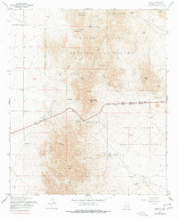
1955 Map of Organ
USGS Topo · Published 1978About this map
The mountain-and-desert landscape of the White Sands Proving Ground dominates this mid-century survey, centered on the strategic San Augustin Pass. The small settlement of Organ sits at the western base of the range, serving as a gateway to a terrain marked by intense mining activity. Prospects such as the Black Prince Mine, Silver King Mine, and the Empire Zinc Mine are scattered across the slopes of San Augustin Peak and Mineral Hill, indicating the area's mineral extraction history. The presence of several Ruins and scattered wells, including Boone Well and Cordova Well, points to the challenges of maintaining permanent habitations in this arid environment. The map also delineates the extensive Military Reservation Boundary, showing the intersection of local resource development and national defense infrastructure in Dona Ana County.
Find a feature on this map
52 named features on this map. Tap any name to fly to it.
Don’t see what you’re looking for? This feature index may not catch every label — zoom into the map to look around manually.
Map Details
Editions of this 1955 Organ Map
4 editions found
Other maps of this area

1891 · Las Cruces
USGS Topo · 1:125,000

1893 · Las Cruces
USGS Topo · 1:125,000

1916 · Tonuco
USGS Topo · 1:125,000

1916 · Point Of Sands
USGS Topo · 1:125,000

1932 · Tonuco
USGS Topo · 1:125,000

1941 · Organ Peak
USGS Topo · 1:62,500

1943 · Parker Lake
USGS Topo · 1:62,500

1943 · Organ Peak
USGS Topo · 1:62,500

1947 · Lake Lucero
USGS Topo · 1:62,500

1948 · Davies Tank
USGS Topo · 1:24,000