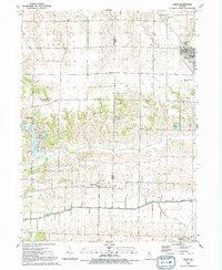
1991 Map of Orion
USGS Topo · Published 1992About this map
Agricultural tablelands and deep-cut creek valleys define the landscape where Rock Island, Henry, and Mercer counties meet. The village of Orion sits at a high crossroads in the northeast, while the Edwards River meanders along the southern border, protected by a long Levee system. This area preserves a dense network of small rural settlements and religious sites, such as Swedona, Ophiem, and the Beulah Ch and cemetery. In the western portion of the quadrangle, several residential lakes including Karl Lake, Renee Lake, and Frye Lake indicate late 20th-century development near Sherrard. Significant local history is found at the Western Twp Cem and Brush Hill Cem, marking the early communities established across the Western and Richland Grove townships.
Find a feature on this map
38 named features on this map. Tap any name to fly to it.
Don’t see what you’re looking for? This feature index may not catch every label — zoom into the map to look around manually.
Map Details
Editions of this 1991 Orion Map
This is the sole edition of this map. No revisions or reprints were ever made.
Other maps of this area

1912 · Milan
USGS Topo · 1:62,500

1923 · Alexis
USGS Topo · 1:62,500

1925 · Alexis
USGS Topo · 1:62,500

1937 · Orion
USGS Topo · 1:62,500

1944 · Milan
USGS Topo · 1:62,500

1947 · Woodhull
USGS Topo · 1:62,500
1948 · Milan
USGS Topo · 1:24,000

1949 · Coal Valley
USGS Topo · 1:24,000

1950 · Milan
USGS Topo · 1:24,000
1953 · Coal Valley
USGS Topo · 1:24,000