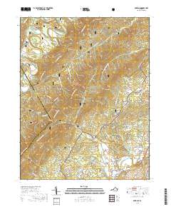
2019 Map of Oriskany
USGS Topo · Published 2019About this map
Oriskany and the surrounding mountain ridges of Jefferson National Forest define this 2019 survey of Botetourt and Craig counties. The landscape is characterized by narrow valleys and high ridges such as Patterson Mtn and Caldwell Mtn, with local life clustered along the winding courses of Craig Creek and Catawba Creek. Genealogists will find a series of family-named burial grounds across the terrain, including Anderson Cem and Tucker Cem near the northern boundary, and Peck Cem to the south. The southern edge of the map shows the historic approach to the town of Fincastle, where the road network transitions from mountain gaps like Lees Gap into the more settled area of Howell Mills. Natural water sources, from the Sulphur Spring to the waters of N Fork Catawba Cr, illustrate the complex drainage patterns of the Virginia Highlands.
Find a feature on this map
65 named features on this map. Tap any name to fly to it.
Don’t see what you’re looking for? This feature index may not catch every label — zoom into the map to look around manually.
Map Details
Editions of this 2019 Oriskany Map
This is the sole edition of this map. No revisions or reprints were ever made.
Other maps of this area

1887 · Lewisburg
USGS Topo · 1:125,000

1890 · Roanoke
USGS Topo · 1:125,000

1890 · Christiansburg
USGS Topo · 1:125,000

1891 · Roanoke
USGS Topo · 1:125,000

1891 · Lewisburg
USGS Topo · 1:125,000

1894 · Natural Bridge
USGS Topo · 1:125,000

1913 · Eagle Rock
USGS Topo · 1:48,000

1915 · Eagle Rock
USGS Topo · 1:62,500

1929 · Roanoke
USGS Topo · 1:48,000

1929 · Salem
USGS Topo · 1:48,000