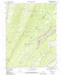
1967 Map of Orkney Springs
USGS Topo · Published 1987About this map
Orkney Springs and the neighboring resort community of Basye center this 1967 survey of the Appalachian corridor where Virginia meets West Virginia. The landscape is defined by the massive ridges of North Mountain and Great North Mountain, containing the remote Lost River Cove. While much of the land is preserved within the George Washington National Forest, the map reveals the mid-century evolution of the area's tourism and recreation economy, most notably seen at the Sky Bryce Airport and the sprawling golf course developments near Bird Haven.
Find a feature on this map
71 named features on this map. Tap any name to fly to it.
Don’t see what you’re looking for? This feature index may not catch every label — zoom into the map to look around manually.
Map Details
Editions of this 1967 Orkney Springs Map
3 editions found
Other maps of this area

1892 · Woodstock
USGS Topo · 1:125,000

1921 · Orkney Springs
USGS Topo · 1:48,000

1923 · Orkney Springs
USGS Topo · 1:62,500

1923 · Edinburg
USGS Topo · 1:62,500

1940 · Orkney Springs
USGS Topo · 1:48,000

1942 · Mt Jackson
USGS Topo · 1:62,500

1943 · Orkney Springs
USGS Topo · 1:62,500

1944 · Orkney Springs
USGS Topo · 1:62,500

1946 · Mt Jackson
USGS Topo · 1:62,500

1947 · Mt Jackson
USGS Topo · 1:62,500