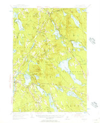
1955 Map of Orland
USGS Topo · Published 1956About this map
The rugged landscape of Hancock and Penobscot Counties is defined by a dense network of glacial ponds and granite peaks during the mid-1950s. Phillips Lake and Green Lake dominate the northern terrain, while the Maine Central railroad cuts through the interior near Lucerne-in-Maine. The area south of Great Pond Mtn reveals a local economy tied to both the water and the earth, featuring the U S Fish Hatchery near Alamoosook Lake and the Annear Copper Mine further south. Numerous family-named hills like Condon Hill and Flying Moose Mtn surround small crossroads like Winkumpaugh Corners, while several rural cemeteries such as Back Ridge Cem and Oak Grove Cem provide valuable touchstones for genealogists studying the families of Orland and East Bucksport.
Find a feature on this map
109 named features on this map. Tap any name to fly to it.
Don’t see what you’re looking for? This feature index may not catch every label — zoom into the map to look around manually.
Map Details
Editions of this 1955 Orland Map
4 editions found
Other maps of this area

1900 · Orland
USGS Topo · 1:62,500

1900 · Bucksport
USGS Topo · 1:62,500

1902 · Orono
USGS Topo · 1:62,500

1902 · Bucksport
USGS Topo · 1:62,500

1902 · Bangor
USGS Topo · 1:62,500

1902 · Castine
USGS Topo · 1:62,500

1904 · Castine
USGS Topo · 1:62,500

1904 · Mount Desert
USGS Topo · 1:62,500

1904 · Bluehill
USGS Topo · 1:62,500

1905 · Penobscot Bay
USGS Topo · 1:125,000