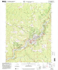
1997 Map of Orleans
USGS Topo · Published 2001About this map
The Klamath River carves through the heart of this terrain, anchoring a landscape where small-scale homesteading and mineral extraction met within the Six Rivers National Forest. In the late 1990s, the settlement of Orleans remains the primary hub, situated near the H.E. Beck Jr Memorial Br. The map reveals a legacy of industrial activity along the riverbanks, evidenced by Dredge Tailings and the Bonda Mine tucked into the gulches. Family-named sites like the Hunter Little Ranch, Reece Homestead, and Dyer Place illustrate the scattered history of land use in this part of Humboldt County. Local genealogy and burial records are preserved at the Orleans Ukonom Cem, while the surrounding mountains, including Sarvorum Mountain and Black Mountain, define the steep boundaries of the river canyon.
Find a feature on this map
59 named features on this map. Tap any name to fly to it.
Don’t see what you’re looking for? This feature index may not catch every label — zoom into the map to look around manually.
Map Details
Editions of this 1997 Orleans Map
This is the sole edition of this map. No revisions or reprints were ever made.
Other maps of this area

1925 · Hoopa
USGS Topo · 1:125,000

1948 · Weed
USGS Topo · 1:250,000

1950 · Weed
USGS Topo · 1:250,000

1952 · Hoopa
USGS Topo · 1:62,500

1952 · Orleans
USGS Topo · 1:62,500

1955 · Salmon Mtn
USGS Topo · 1:62,500

1955 · Forks of Salmon
USGS Topo · 1:62,500

1958 · Weed
USGS Topo · 1:250,000

1963 · Weed
USGS Topo · 1:250,000

1974 · Orleans Mtn.
USGS Topo · 1:24,000