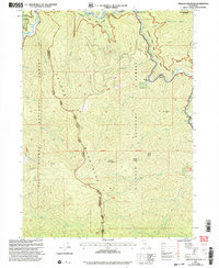
2001 Map of Orleans Mountain
USGS Topo · Published 2004About this map
Orleans Mountains define the topography of this high-elevation region where the Klamath River and Salmon River converge. At the turn of the 21st century, the landscape reflects a heritage of remote settlements and resource extraction, with the Indian Bottom Mine and Boomer Mine situated near the steep drainage of Ti Creek. The convergence of the Ukonom Ranger District and Orleans Ranger District highlights the administrative complexity of managing these lands within the Klamath National Forest.
Find a feature on this map
50 named features on this map. Tap any name to fly to it.
Don’t see what you’re looking for? This feature index may not catch every label — zoom into the map to look around manually.
Map Details
Editions of this 2001 Orleans Mountain Map
This is the sole edition of this map. No revisions or reprints were ever made.
Other maps of this area

1925 · Hoopa
USGS Topo · 1:125,000

1948 · Weed
USGS Topo · 1:250,000

1950 · Weed
USGS Topo · 1:250,000

1952 · Hoopa
USGS Topo · 1:62,500

1952 · Orleans
USGS Topo · 1:62,500

1955 · Salmon Mtn
USGS Topo · 1:62,500

1955 · Forks of Salmon
USGS Topo · 1:62,500

1958 · Weed
USGS Topo · 1:250,000

1963 · Weed
USGS Topo · 1:250,000

1974 · Orleans Mtn.
USGS Topo · 1:24,000