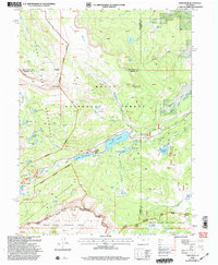
2000 Map of Orno Peak
USGS Topo · Published 2004About this map
The Flat Tops dominate this high-altitude landscape, where the boundaries of Garfield, Routt, and Rio Blanco counties converge. The terrain is defined by dramatic plateaus like Little Flat Tops and prominent summits including Orno Peak and Maggies Nipple. Water management is central to the area's geography, evidenced by the significant presence of Yamcolo Reservoir, Stillwater Reservoir, and Gardner Park Reservoir. These man-made features contrast with the natural high-country basins of Heart Lake and the cluster of Twin Mandall Lakes.
Find a feature on this map
46 named features on this map. Tap any name to fly to it.
Don’t see what you’re looking for? This feature index may not catch every label — zoom into the map to look around manually.
Map Details
Editions of this 2000 Orno Peak Map
This is the sole edition of this map. No revisions or reprints were ever made.
Other maps of this area

1927 · Glenwood Springs
USGS Topo · 1:125,000

1930 · Glenwood Springs
USGS Topo · 1:125,000

1954 · Craig
USGS Topo · 1:250,000

1957 · Craig
USGS Topo · 1:250,000

1957 · Leadville
USGS Topo · 1:250,000

1958 · Craig
USGS Topo · 1:250,000

1959 · Leadville
USGS Topo · 1:250,000

1960 · Leadville
USGS Topo · 1:250,000

1960 · Craig
USGS Topo · 1:250,000

1962 · Leadville
USGS Topo · 1:250,000