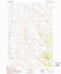
1989 Map of Orofino Creek
USGS Topo · Published 1989About this map
The Clark Fork river dominates the western margin of this area, flowing through a landscape defined by sharp drainage divides and high ridges in the late twentieth century. To the southeast, the terrain rises into the Deerlodge National Forest, where O'Donnell Mountain stands as a prominent landmark. This territory is marked by a complex network of named drainages, including Orofino Creek and Caribou Creek, which feed into the primary river valley. The map documents the boundary between Powell and Deer Lodge counties, cutting across the southern terrain. This 1989 provisional edition, which incorporates field data from as early as 1959, captures a specific moment in Montana's land management history, showing the established section lines and water systems before further modern development. Small settlements and local place names like Racetrack and Dempsey Creek provide anchor points for understanding the early regional transport and ranching patterns of the valley.
Find a feature on this map
16 named features on this map. Tap any name to fly to it.
Don’t see what you’re looking for? This feature index may not catch every label — zoom into the map to look around manually.
Map Details
Editions of this 1989 Orofino Creek Map
This is the sole edition of this map. No revisions or reprints were ever made.
Other maps of this area

1889 · Helena
USGS Topo · 1:250,000

1893 · Helena
USGS Topo · 1:250,000

1899 · Helena
USGS Topo · 1:250,000

1903 · Helena
USGS Topo · 1:250,000

1947 · Butte
USGS Topo · 1:250,000

1958 · Butte
USGS Topo · 1:250,000

1959 · Butte North
USGS Topo · 1:62,500

1959 · Deer Lodge
USGS Topo · 1:62,500

1960 · Butte
USGS Topo · 1:250,000

1961 · Anaconda
USGS Topo · 1:62,500