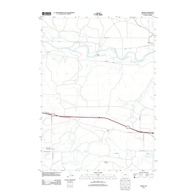
2012 Map of Orpha
USGS Topo · Published 2012About this map
The N Platte River meanders across this Converse County landscape, defining the northern geography near the settlements of Alberta and Orpha. This early 21st-century mapping reveals a terrain shaped by water and ranching, where Sage Cr and Alkali Gulch feed into the primary river valley. Further south, the prominent Table Mountain stands near Spring Canyon Cr, overlooking a series of agricultural operations including the Mueller Ranch and Sewell Ranch. One of the most distinctive features is Infant Geyser, located north of the Interstate, highlighting the unique geothermal or hydrologic activity in this part of Wyoming. Transportation is anchored by the Old Douglas Hwy and the local Chamberlain Brothers Ranch Airport, which supports the area's remote ranching and industrial needs, such as those accessed via Tank Farm Rd.
Find a feature on this map
26 named features on this map. Tap any name to fly to it.
Don’t see what you’re looking for? This feature index may not catch every label — zoom into the map to look around manually.
Map Details
Editions of this 2012 Orpha Map
This is the sole edition of this map. No revisions or reprints were ever made.
Other maps of this area

1949 · Sundquist Ranch
USGS Topo · 1:24,000

1949 · Orpha
USGS Topo · 1:24,000

1949 · Careyhurst
USGS Topo · 1:24,000

1949 · Gilbert Lake
USGS Topo · 1:24,000

1949 · Douglas
USGS Topo · 1:24,000

1949 · Leuenberger Ranch
USGS Topo · 1:24,000

1949 · Chalk Buttes
USGS Topo · 1:24,000

1950 · Careyhurst
USGS Topo · 1:24,000

1950 · Gilbert Lake
USGS Topo · 1:24,000

1950 · Leuenberger Ranch
USGS Topo · 1:24,000