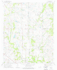
1974 Map of Orr
USGS Topo · Published 1977About this map
Orr serves as the primary community focal point in this south-central Oklahoma landscape, situated near the boundary between Jefferson, Carter, and Love Counties. In the mid-1970s, the region was characterized by a mix of agricultural activity and industrial extraction, with an active Oil Field and scattered Oil Wells dotting the northern terrain. The social life of the area is anchored by the Center Point Ch and the Orr Cem, offering valuable data for genealogists and local historians studying rural settlement patterns. The topography is defined by the winding paths of North Mud Creek and Clear Creek, which eventually feed into the southern drainages of Sparks Branch and Sandy Creek. Near the southern border, a Gaging Station monitor levels along the creek bed, while landmarks like Bald Hill rise above the surrounding creek bottoms and rolling pastures.
Find a feature on this map
19 named features on this map. Tap any name to fly to it.
Don’t see what you’re looking for? This feature index may not catch every label — zoom into the map to look around manually.
Map Details
Editions of this 1974 Orr Map
This is the sole edition of this map. No revisions or reprints were ever made.
Other maps of this area

1901 · Addington
USGS Topo · 1:125,000

1901 · Ardmore
USGS Topo · 1:125,000

1902 · Gainesville
USGS Topo · 1:125,000

1905 · Montague
USGS Topo · 1:125,000

1918 · Ardmore
USGS Topo · 1:125,000

1943 · Gainesville
USGS Topo · 1:125,000

1954 · Sherman
USGS Topo · 1:250,000

1957 · Ardmore
USGS Topo · 1:250,000

1958 · Sherman
USGS Topo · 1:250,000

1963 · Ardmore
USGS Topo · 1:250,000