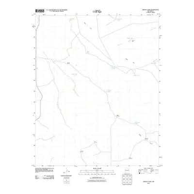
2010 Map of Ortega Tank
USGS Topo · Published 2010About this map
Mesa Rica dominates the northern landscape of this region in San Miguel County, where ranching infrastructure and seasonal water sources define the human footprint. The map documents a network of essential water improvements for livestock, including the Aragon Dam and numerous family-named catchment points like La Munyan Tank, Smith Tank, and Benavidez Tank.
Find a feature on this map
24 named features on this map. Tap any name to fly to it.
Don’t see what you’re looking for? This feature index may not catch every label — zoom into the map to look around manually.
Map Details
Editions of this 2010 Ortega Tank Map
This is the sole edition of this map. No revisions or reprints were ever made.
Other maps of this area

1954 · Santa Fe
USGS Topo · 1:250,000

1958 · Santa Fe
USGS Topo · 1:250,000

1964 · Neafus Ranch
USGS Topo · 1:24,000

1964 · Muniz Canyon
USGS Topo · 1:24,000

1964 · Gate Canyon
USGS Topo · 1:24,000

1964 · Newkirk
USGS Topo · 1:24,000
1964 · Montoya
USGS Topo · 1:24,000

1964 · Ortega Tank
USGS Topo · 1:24,000

1967 · Tenaja Mesa
USGS Topo · 1:24,000

1967 · Monument Point
USGS Topo · 1:24,000