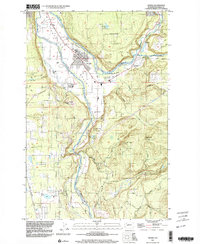
1997 Map of Orting
USGS Topo · Published 2003About this map
The Puyallup Valley serves as the dominant geographical feature of this Pierce County survey, where the confluence of the Carbon River and Puyallup River shapes the local landscape. The settlement of Orting is detailed with its organized street grid, Athletic Field, and the sprawling grounds of the State Soldiers Home. This map records a landscape transitioning from its heavy industrial roots toward a more residential and recreational character, evidenced by the presence of a Golf Course alongside remnants of the region's extractive past.
Find a feature on this map
38 named features on this map. Tap any name to fly to it.
Don’t see what you’re looking for? This feature index may not catch every label — zoom into the map to look around manually.
Map Details
Editions of this 1997 Orting Map
This is the sole edition of this map. No revisions or reprints were ever made.
Other maps of this area

1897 · Tacoma
USGS Topo · 1:125,000

1900 · Tacoma
USGS Topo · 1:125,000

1937 · Eatonville
USGS Topo · 1:125,000

1941 · Tanwax Lake
USGS Topo · 1:62,500

1941 · Tacoma South
USGS Topo · 1:62,500

1942 · Lake Tapps
USGS Topo · 1:62,500

1944 · Lake Tapps
USGS Topo · 1:62,500

1944 · Tacoma South
USGS Topo · 1:62,500

1944 · Ohop Valley
USGS Topo · 1:62,500

1949 · Ohop Valley
USGS Topo · 1:62,500