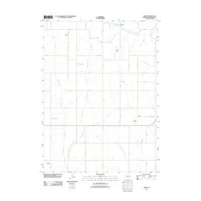
2011 Map of Orum
USGS Topo · Published 2011About this map
Orum sits at the heart of this Washington County landscape, where the agricultural grid is defined by a dense network of county roads and meandering waterways. The drainage patterns of eastern Nebraska are clearly visible as Bell Creek and Little Bell Creek flow southward, while New York Creek and the Northwest Branch Papillion Creek carve through the eastern sections. Local infrastructure and land use are evidenced by landmarks like the Orum Aerodrome and water management features such as Mathiesen Dam and Sprick Dam.
Find a feature on this map
37 named features on this map. Tap any name to fly to it.
Don’t see what you’re looking for? This feature index may not catch every label — zoom into the map to look around manually.
Map Details
Editions of this 2011 Orum Map
This is the sole edition of this map. No revisions or reprints were ever made.
Other maps of this area

1893 · Fremont
USGS Topo · 1:125,000

1896 · Fremont
USGS Topo · 1:125,000

1955 · Fremont
USGS Topo · 1:250,000

1957 · Fremont
USGS Topo · 1:250,000

1958 · Fremont
USGS Topo · 1:250,000

1966 · Nickerson
USGS Topo · 1:24,000

1966 · Nickerson NW
USGS Topo · 1:24,000

1968 · Fremont East
USGS Topo · 1:24,000

1968 · Kennard
USGS Topo · 1:24,000
1968 · Arlington
USGS Topo · 1:24,000