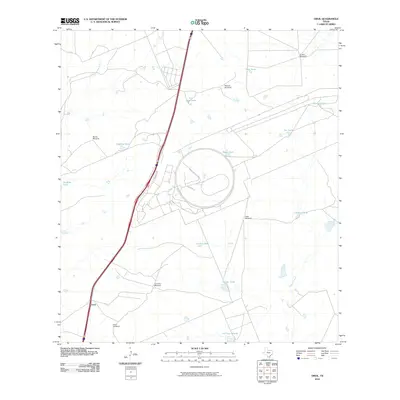
2010 Map of Orvil
USGS Topo · Published 2010About this map
The small settlement of Orvil anchors this Webb County landscape, where the semi-arid South Texas brush country is defined by an extensive network of water management features. Ranching infrastructure dominates the topography, with family-named or descriptive landmarks like the El Jano Windmill, Macana Windmill, and Tasal Windmill serving as vital nodes across the territory. These mechanical points, along with numerous earthen reservoirs such as Royal Tank and Cerritos Tank, reflect a landscape adapted for livestock in a region where natural water sources like Sombrerito Creek and Chacon Creek are ephemeral. A prominent circular feature east of Regional Dr suggests a specialized industrial or testing facility, contrasting with the traditional rural character of nearby La Presa Grande. This survey documents a transition between historical ranching heritage and modern infrastructure in the vicinity of Laredo.
Find a feature on this map
21 named features on this map. Tap any name to fly to it.
Don’t see what you’re looking for? This feature index may not catch every label — zoom into the map to look around manually.
Map Details
Editions of this 2010 Orvil Map
This is the sole edition of this map. No revisions or reprints were ever made.
Other maps of this area

1956 · Las Tiendas
USGS Topo · 1:62,500

1956 · Islitas
USGS Topo · 1:62,500

1956 · Laredo East
USGS Topo · 1:62,500

1956 · Webb
USGS Topo · 1:62,500

1956 · Laredo
USGS Topo · 1:250,000

1965 · Laredo West
USGS Topo · 1:24,000

1965 · Orvil
USGS Topo · 1:24,000

1965 · Cuervo Creek
USGS Topo · 1:24,000

1965 · Cibolo Ranch
USGS Topo · 1:24,000

1965 · Nido Ranch
USGS Topo · 1:24,000