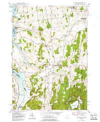
1949 Map of Orwell
USGS Topo · Published 1988About this map
The Rutland railroad corridor anchors the landscape of this 1949 survey, connecting the villages of East Shoreham and North Orwell. The terrain is characterized by a series of north-south ridges and low hills like Barnum Hill and Hardigan Hill, interspersed with water systems such as the Lemon Fair River and the winding East Creek. The shoreline of Lake Champlain to the west features significant points of entry including Larrabees Point and Chipman Point, while inland, the settlement of Orwell serves as a central hub.
Find a feature on this map
67 named features on this map. Tap any name to fly to it.
Don’t see what you’re looking for? This feature index may not catch every label — zoom into the map to look around manually.
Map Details
Editions of this 1949 Orwell Map
3 editions found
Other maps of this area

1893 · Whitehall
USGS Topo · 1:62,500

1894 · Ticonderoga
USGS Topo · 1:62,500

1895 · Whitehall
USGS Topo · 1:62,500

1895 · Castleton
USGS Topo · 1:62,500

1896 · Ticonderoga
USGS Topo · 1:62,500

1897 · Castleton
USGS Topo · 1:62,500

1898 · Whitehall
USGS Topo · 1:62,500

1902 · Whitehall
USGS Topo · 1:62,500

1902 · Ticonderoga
USGS Topo · 1:62,500

1902 · Brandon
USGS Topo · 1:62,500