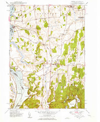
1949 Map of Orwell
USGS Topo · Published 1949About this map
The Rutland Railroad corridor serves as the industrial backbone of this Vermont landscape, threading through the eastern agricultural plains and connecting depots at Orwell Sta and Larrabees Point. The 1949 topography reveals a well-established network of rural civic life, marked by numerous small educational and religious sites including the Smith Sch, Hough Crossing Sch, and St Pauls Cem. To the west, the map details the intricate shoreline of Lake Champlain, featuring landmarks like Chipman Point and Gourlie Point alongside several smaller inlets such as Beadles Cove. The southern portion of the quadrangle shifts toward a more varied terrain of ridges and basins, home to Sunset Lake and Sunrise Lake, situated near the rugged elevations of The Pinnacle. This transition from the river-fed lowlands of the Lemon Fair River to the lakefront coves highlights a mid-century economy built on rail transit and scattered farming hamlets.
Find a feature on this map
63 named features on this map. Tap any name to fly to it.
Don’t see what you’re looking for? This feature index may not catch every label — zoom into the map to look around manually.
Map Details
Editions of this 1949 Orwell Map
3 editions found
Other maps of this area

1893 · Whitehall
USGS Topo · 1:62,500

1894 · Ticonderoga
USGS Topo · 1:62,500

1895 · Whitehall
USGS Topo · 1:62,500

1895 · Castleton
USGS Topo · 1:62,500

1896 · Ticonderoga
USGS Topo · 1:62,500

1897 · Castleton
USGS Topo · 1:62,500

1898 · Whitehall
USGS Topo · 1:62,500

1902 · Whitehall
USGS Topo · 1:62,500

1902 · Ticonderoga
USGS Topo · 1:62,500

1902 · Brandon
USGS Topo · 1:62,500