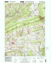
1999 Map of Orwigsburg
USGS Topo · Published 2001About this map
The Schuylkill River and its tributary, the Little Schuylkill River, anchor this late twentieth-century landscape of south-central Schuylkill County. The map details the developed core of Orwigsburg and the surrounding township of Brunswick, where the transition from industrial extraction to residential and recreational land use is evident. Evidence of the region’s anthracite heritage appears in the north with a Strip Mine near Middleport, while the southern portion of the sheet shows a shift toward community features like the Drive-in Theater and Golf Course.
Find a feature on this map
38 named features on this map. Tap any name to fly to it.
Don’t see what you’re looking for? This feature index may not catch every label — zoom into the map to look around manually.
Map Details
Editions of this 1999 Orwigsburg Map
This is the sole edition of this map. No revisions or reprints were ever made.
Other maps of this area

1889 · Hazleton
USGS Topo · 1:62,500

1889 · Pottsville
USGS Topo · 1:62,500

1891 · Hazleton
USGS Topo · 1:62,500

1891 · Pottsville
USGS Topo · 1:62,500

1892 · Mahanoy
USGS Topo · 1:62,500

1893 · Hazleton
USGS Topo · 1:62,500

1893 · Mahanoy
USGS Topo · 1:62,500

1909 · Hamburg
USGS Topo · 1:62,500

1911 · Hamburg
USGS Topo · 1:62,500

1944 · Pottsville
USGS Topo · 1:24,000
Featured Places
- Orwigsburg, PA
- New Philadelphia, PA
- Deer Lake, West Brunswick Township
- Middleport, PA
- North Manheim Township, PA