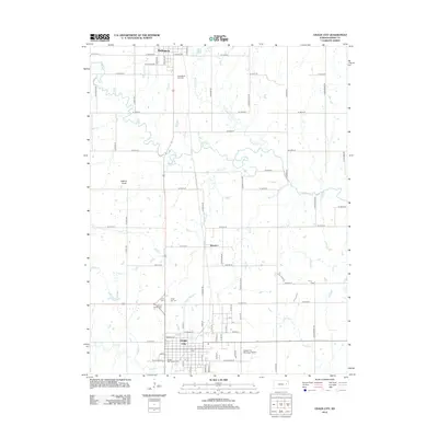
2012 Map of Osage City
USGS Topo · Published 2012About this map
Osage City serves as a primary hub in this Kansas landscape, defined by a dense grid of residential streets and civic landmarks including the Po and the Osage City Fairgrounds. To the north, the smaller settlements of Burlingame and Peterton are connected by a north-south transit corridor, while the surrounding countryside is partitioned into a systematic grid of section roads. The terrain is shaped by a complex network of waterways, most notably Dragoon Cr, Switzler Cr, and Smith Cr, which meander through the prairie toward the southeast. Genealogists will find several significant burial grounds documented across the quadrangle, such as Burlingame City Cem, Mount Calvary Cem, and Union Cem. The local aviation infrastructure is represented by the Osage City Municipal Airport located just east of the main town site, while Elkhorn Knob provides a distinct topographic point of reference in the western portion of the survey.
Find a feature on this map
72 named features on this map. Tap any name to fly to it.
Don’t see what you’re looking for? This feature index may not catch every label — zoom into the map to look around manually.
Map Details
Editions of this 2012 Osage City Map
This is the sole edition of this map. No revisions or reprints were ever made.
Other maps of this area

1889 · Burlingame
USGS Topo · 1:125,000

1894 · Burlingame
USGS Topo · 1:125,000

1947 · Lawrence
USGS Topo · 1:250,000

1950 · Lawrence
USGS Topo · 1:250,000

1952 · Harveyville
USGS Topo · 1:24,000

1952 · Burlingame
USGS Topo · 1:24,000

1955 · Carbondale
USGS Topo · 1:24,000

1956 · Lawrence
USGS Topo · 1:250,000

1961 · Lawrence
USGS Topo · 1:250,000
1965 · Lyndon
USGS Topo · 1:24,000