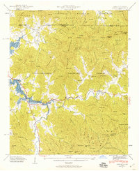
1941 Map of Osborn
USGS Topo · Published 1941About this map
Chatuge Lake dominates the western landscape of this Georgia and North Carolina border region, its newly formed shoreline following the rising waters of the Hiwassee River valley. The 1941 survey captures a moment of transition for the settlement of Osborn, located along the banks of Hightower Creek as the valley was being shaped by the Tennessee Valley Authority’s reservoir project. The map reveals a dense network of rural infrastructure, including Lower Hightower Sch and the Macedonia Ch, alongside numerous family-named mountain features like Eagle Mountain and Sharptop Ridge. To the east, the Appalachian Trail winds through the high gaps of the Blue Ridge, passing the Hooper Gap Shelter. The concentration of schools and churches, such as the Upper Bell Sch and Boyd Chapel, illustrates the distributed nature of these mountain communities before modern consolidation.
Find a feature on this map
142 named features on this map. Tap any name to fly to it.
Don’t see what you’re looking for? This feature index may not catch every label — zoom into the map to look around manually.
Map Details
Editions of this 1941 Osborn Map
2 editions found
Other maps of this area

1886 · Dahlonega
USGS Topo · 1:125,000

1892 · Dahlonega
USGS Topo · 1:125,000

1896 · Dahlonega
USGS Topo · 1:125,000

1903 · Dahlonega
USGS Topo · 1:125,000

1935 · Osborn
USGS Topo · 1:24,000

1935 · Rainbow Springs
USGS Topo · 1:24,000

1935 · Shooting Creek
USGS Topo · 1:24,000

1935 · Wayah Bald
USGS Topo · 1:48,000

1935 · Hightower Bald
USGS Topo · 1:24,000

1935 · Tray Mountain
USGS Topo · 1:24,000