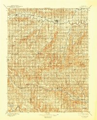
1896 Map of Osborne
USGS Topo · Published 1944About this map
The South Fork Solomon River defines the northern landscape of this Kansas region, where the Pacific RR follows the valley through early rail towns like Alton and Osborne. Surveyed in the 1890s, the map reveals a high density of small rural settlements and post offices that served a growing agricultural population. To the south, the topography transitions into the drainage of Wolf Creek and Paradise Creek, where the boundary between Osborne Co and Russell Co is clearly marked.
Find a feature on this map
64 named features on this map. Tap any name to fly to it.
Don’t see what you’re looking for? This feature index may not catch every label — zoom into the map to look around manually.
Map Details
Editions of this 1896 Osborne Map
4 editions found
Other maps of this area

1893 · Smith Center
USGS Topo · 1:125,000

1893 · Phillipsburg
USGS Topo · 1:125,000

1894 · Ellsworth
USGS Topo · 1:125,000

1894 · Mankato
USGS Topo · 1:125,000

1894 · Beloit
USGS Topo · 1:125,000

1896 · Osborne
USGS Topo · 1:125,000

1896 · Russell
USGS Topo · 1:125,000

1896 · Hays
USGS Topo · 1:125,000

1896 · Plainville
USGS Topo · 1:125,000

1953 · Downs South
USGS Topo · 1:24,000