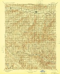
1896 Map of Osborne
USGS Topo · Published 1924About this map
The South Fork Solomon River and the Missouri Pacific RR define the northern valley of this North Central Kansas landscape, where the town of Osborne serves as a central hub. Surveyed in 1892, the map captures a grid of rural townships including Grant, Hawkeye, and Bloom, reflecting the early agricultural settlement patterns of the late nineteenth century. To the south, the Union Pacific RR cuts through the territory near Lucas and Waldo, highlighting the importance of rail connectivity for the movement of livestock and grain from isolated outposts like Meade Ranch. The terrain transitions from the river lowlands to the higher elevation of Round Mound, while smaller communities such as Bristow, Corinth, and Paradise dot the section lines, many of which evolved around early post offices and school districts. This survey provides a primary source for understanding the development of Osborne County and Russell County before modern highway expansion altered these local road networks.
Find a feature on this map
59 named features on this map. Tap any name to fly to it.
Don’t see what you’re looking for? This feature index may not catch every label — zoom into the map to look around manually.
Map Details
Editions of this 1896 Osborne Map
4 editions found
Other maps of this area

1893 · Smith Center
USGS Topo · 1:125,000

1893 · Phillipsburg
USGS Topo · 1:125,000

1894 · Ellsworth
USGS Topo · 1:125,000

1894 · Mankato
USGS Topo · 1:125,000

1894 · Beloit
USGS Topo · 1:125,000

1896 · Osborne
USGS Topo · 1:125,000

1896 · Russell
USGS Topo · 1:125,000

1896 · Hays
USGS Topo · 1:125,000

1896 · Plainville
USGS Topo · 1:125,000

1953 · Downs South
USGS Topo · 1:24,000