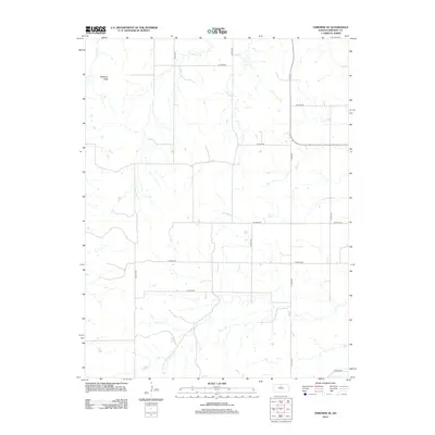
2012 Map of Osborne SE
USGS Topo · Published 2012About this map
Medicine Peak rises as a prominent landmark in this portion of Osborne County, overlooking a landscape defined by the drainage network of the Solomon River valley's northern tributaries. This 2012 survey illustrates a highly structured agricultural grid, where section-line roads like S 60th Ave and W 190th Dr provide access to the rolling plains. The hydrology is dominated by the seasonal paths of Twin Cr, Center Twin Cr, and E Twin Cr, which carve shallow valleys through the terrain. The presence of Cord 691 and various numbered drives reflects the modern rural addressing system used to navigate this sparsely populated farming region. Researchers will find a clear record of land division and water resources near the confluence area of Carr Cr, typical of the High Plains agricultural interface.
Find a feature on this map
19 named features on this map. Tap any name to fly to it.
Don’t see what you’re looking for? This feature index may not catch every label — zoom into the map to look around manually.
Map Details
Editions of this 2012 Osborne SE Map
This is the sole edition of this map. No revisions or reprints were ever made.
Other maps of this area

1894 · Beloit
USGS Topo · 1:125,000

1896 · Osborne
USGS Topo · 1:125,000

1953 · Downs South
USGS Topo · 1:24,000

1953 · Waconda Springs
USGS Topo · 1:24,000

1953 · Osborne
USGS Topo · 1:24,000

1955 · Beloit
USGS Topo · 1:250,000

1959 · Beloit
USGS Topo · 1:250,000

1967 · Hunter
USGS Topo · 1:24,000

1978 · Osborne SW
USGS Topo · 1:24,000
1978 · Tipton
USGS Topo · 1:24,000