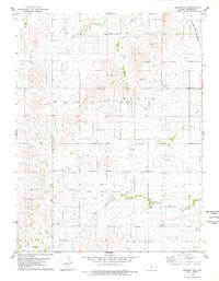
1978 Map of Osborne SE
USGS Topo · Published 1979About this map
Atchison Topeka and Santa Fe railroad tracks skirt the northeastern corner of this Kansas landscape, serving as a vital industrial artery through the rural townships of Bloom and Delhi. The topography is defined by the drainage systems of Twin Creek, Center Twin Creek, and East Twin Creek in the north, while Carr Creek winds through the southern portion of the quadrangle. This 1970s survey illustrates a region shaped by agricultural section lines and small-scale extractive industries, evidenced by several Quarry and Gravel Pits locations. The division of land into named blocks such as Hancock and Winfield reflects the organized township structure characteristic of the Great Plains, providing a clear view of the land use and water resources available to residents during this era.
Find a feature on this map
12 named features on this map. Tap any name to fly to it.
Don’t see what you’re looking for? This feature index may not catch every label — zoom into the map to look around manually.
Map Details
Editions of this 1978 Osborne SE Map
This is the sole edition of this map. No revisions or reprints were ever made.
Other maps of this area

1894 · Beloit
USGS Topo · 1:125,000

1896 · Osborne
USGS Topo · 1:125,000

1953 · Downs South
USGS Topo · 1:24,000

1953 · Waconda Springs
USGS Topo · 1:24,000

1953 · Osborne
USGS Topo · 1:24,000

1955 · Beloit
USGS Topo · 1:250,000

1959 · Beloit
USGS Topo · 1:250,000

1967 · Hunter
USGS Topo · 1:24,000

1978 · Osborne SW
USGS Topo · 1:24,000
1978 · Tipton
USGS Topo · 1:24,000