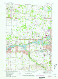
1969 Map of Osceola
USGS Topo · Published 1980About this map
The St Joseph River defines the central corridor of this northern Indiana landscape, where the town of Osceola sits at the confluence with Baugo Creek. During the late 1960s, this area reflects a complex transition from rural agricultural land to suburban expansion between South Bend and Elkhart. The river's path is marked by distinctive features such as Eagle Point and Baugo Bay, while the surrounding townships of Harris, Penn, and Baugo are interconnected by a dense network of transit lines. The Indiana Toll Road and major rail arteries like the Grand Trunk Western Railroad and Penn Central cut across the territory, supporting local industry and the nearby Elkhart Municipal Airport. Notable community landmarks include the Northern Indiana Conference Grounds and several educational sites like Penn High School and Schmucke School.
Find a feature on this map
59 named features on this map. Tap any name to fly to it.
Don’t see what you’re looking for? This feature index may not catch every label — zoom into the map to look around manually.
Map Details
Editions of this 1969 Osceola Map
4 editions found
Other maps of this area

1945 · Cassopolis
USGS Topo · 1:62,500

1947 · Cassopolis
USGS Topo · 1:62,500

1948 · Vandalia
USGS Topo · 1:62,500

1949 · Vandalia
USGS Topo · 1:62,500

1953 · Fort Wayne
USGS Topo · 1:250,000

1953 · Chicago
USGS Topo · 1:250,000

1956 · Fort Wayne
USGS Topo · 1:250,000

1957 · Chicago
USGS Topo · 1:250,000

1958 · South Bend East
USGS Topo · 1:24,000

1958 · Osceola
USGS Topo · 1:24,000