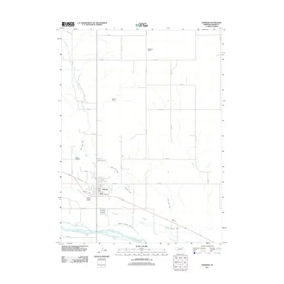
2011 Map of Oshkosh
USGS Topo · Published 2011About this map
Oshkosh and the surrounding high plains of Garden County are defined by an intricate system of water management along the North Platte River. This 2011 survey illustrates the complex hydraulic network essential to the region, featuring the North River Canal, Oshkosh Canal, and Midland Overland Canal that parallel the river's course. North of the primary settlement, the landscape transitions into the Antelope Valley, where Lost Creek winds through a grid of rural roads. Local history and genealogy are anchored by Saint Elizabeths Cemetery and the Oshkosh Cemetery, while the presence of the Garden County Airport and Dougs Texaco Campground highlights the area's role as a regional transit and service hub. Further landmarks such as Dorman Dam and the Oshkosh Post Office provide fixed points of reference for researchers studying the modern infrastructure of this Western Nebraska community.
Find a feature on this map
32 named features on this map. Tap any name to fly to it.
Don’t see what you’re looking for? This feature index may not catch every label — zoom into the map to look around manually.
Map Details
Editions of this 2011 Oshkosh Map
This is the sole edition of this map. No revisions or reprints were ever made.
Other maps of this area

1900 · Chappell
USGS Topo · 1:125,000

1949 · Rackett
USGS Topo · 1:62,500

1950 · Crescent Lake
USGS Topo · 1:62,500

1951 · Rackett
USGS Topo · 1:62,500

1954 · Scottsbluff
USGS Topo · 1:250,000

1958 · Scottsbluff
USGS Topo · 1:250,000
1971 · Twin Buttes
USGS Topo · 1:24,000

1971 · Barn Butte
USGS Topo · 1:24,000

1971 · Oshkosh SW
USGS Topo · 1:24,000

1971 · Coumbe Bluff
USGS Topo · 1:24,000