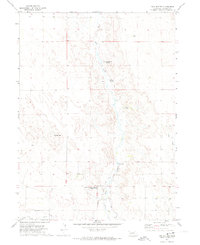
1971 Map of Twin Buttes
USGS Topo · Published 1974About this map
Bluewater Battlefield Overlook Site sits at the southern edge of this Nebraska landscape, overlooking a complex system of irrigation that supported high-plains agriculture in the 1970s. The mapping shows an intricate network of water management, including the Blue Creek Canal, Hooper Canal, and Paisley Canal, all drawing from Blue Creek as it winds southward. These man-made channels contrast with the natural springs like Rattlesnake Spring and Dugout Spring that dot the higher elevations.
Find a feature on this map
18 named features on this map. Tap any name to fly to it.
Don’t see what you’re looking for? This feature index may not catch every label — zoom into the map to look around manually.
Map Details
Editions of this 1971 Twin Buttes Map
This is the sole edition of this map. No revisions or reprints were ever made.
Other maps of this area

1900 · Chappell
USGS Topo · 1:125,000

1949 · Rackett
USGS Topo · 1:62,500

1950 · Crescent Lake
USGS Topo · 1:62,500

1951 · Rackett
USGS Topo · 1:62,500

1954 · Scottsbluff
USGS Topo · 1:250,000

1958 · Scottsbluff
USGS Topo · 1:250,000
1971 · Ruthton
USGS Topo · 1:24,000

1971 · Barn Butte
USGS Topo · 1:24,000
1971 · Old Baldy
USGS Topo · 1:24,000
1971 · Lewellen
USGS Topo · 1:24,000