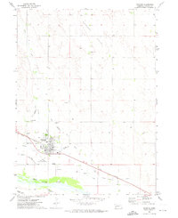
1971 Map of Oshkosh
USGS Topo · Published 1974About this map
The town of Oshkosh sits at a historic intersection of Western migration and Nebraska prairie life, flanked by the North Platte River and the high bluffs of Antelope Valley. This early 1970s landscape preserves the deep history of the frontier, marking the approximate paths of the Emigrant Trail and the Oregon Trail as they paralleled the river valley. The town's grid is centered near the Union Pacific tracks, showing a mix of modern infrastructure like the Oshkosh Municipal Airport and sewage disposal facilities alongside recreational hubs like the Oshkosh Country Club.
Find a feature on this map
25 named features on this map. Tap any name to fly to it.
Don’t see what you’re looking for? This feature index may not catch every label — zoom into the map to look around manually.
Map Details
Editions of this 1971 Oshkosh Map
This is the sole edition of this map. No revisions or reprints were ever made.
Other maps of this area

1900 · Chappell
USGS Topo · 1:125,000

1949 · Rackett
USGS Topo · 1:62,500

1950 · Crescent Lake
USGS Topo · 1:62,500

1951 · Rackett
USGS Topo · 1:62,500

1954 · Scottsbluff
USGS Topo · 1:250,000

1958 · Scottsbluff
USGS Topo · 1:250,000
1971 · Twin Buttes
USGS Topo · 1:24,000

1971 · Barn Butte
USGS Topo · 1:24,000

1971 · Oshkosh SW
USGS Topo · 1:24,000

1971 · Coumbe Bluff
USGS Topo · 1:24,000