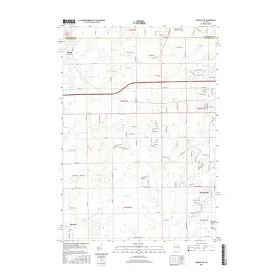
2016 Map of Oshkosh NE
USGS Topo · Published 2016About this map
The boundary between Outagamie Co and Winnebago Co segments this landscape of the upper Fox Valley, where agricultural roots meet expanding aviation infrastructure. Small settlements such as Allenville and Medina Junction provide historical touchstones for genealogists, with the Allenville Cem serving as a localized point of interest for family researchers. The terrain is defined by its drainage into the Rat River and Arrowhead River, alongside smaller waterways like Daggets Cr and the Neenah Slough. This 2016 survey documents the proximity of three distinct aviation facilities—the Outagamie County Regional Airport, Brennand Airport, and the uniquely named With Wings and a Halo Airport—illustrating the area's importance to regional transportation and private flight. Residential growth is visible in the northwest section of Neenah, characterized by winding drives and park spaces like Greenlawn Memorial Park.
Find a feature on this map
109 named features on this map. Tap any name to fly to it.
Don’t see what you’re looking for? This feature index may not catch every label — zoom into the map to look around manually.
Map Details
Editions of this 2016 Oshkosh NE Map
This is the sole edition of this map. No revisions or reprints were ever made.
Other maps of this area

1911 · Neenah
USGS Topo · 1:62,500

1955 · Neenah
USGS Topo · 1:62,500

1955 · Appleton
USGS Topo · 1:24,000

1955 · Appleton
USGS Topo · 1:62,500

1955 · Neenah
USGS Topo · 1:24,000

1955 · Green Bay
USGS Topo · 1:250,000

1956 · New London
USGS Topo · 1:48,000

1961 · Oshkosh
USGS Topo · 1:24,000

1961 · Oshkosh
USGS Topo · 1:62,500

1961 · Oshkosh NE
USGS Topo · 1:24,000