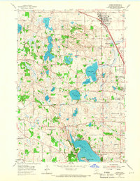
1955 Map of Osseo
USGS Topo · Published 1966About this map
The town of Osseo serves as the focal point for this mid-century survey, positioned along the Great Northern railway as suburban expansion began to reshape the landscape of northern Hennepin County. The area is defined by a dense concentration of glacial lakes, with Medicine Lake and Fish Lake anchoring the southern and central terrain respectively. These water bodies, along with smaller features like Cedar Island Lake and Pomerleau Lake, influenced early settlement patterns and the placement of community institutions.
Find a feature on this map
41 named features on this map. Tap any name to fly to it.
Don’t see what you’re looking for? This feature index may not catch every label — zoom into the map to look around manually.
Map Details
Editions of this 1955 Osseo Map
2 editions found

Other maps of this area

1896 · Minneapolis
USGS Topo · 1:62,500

1901 · Minneapolis
USGS Topo · 1:62,500

1902 · Anoka
USGS Topo · 1:62,500

1905 · Minnetonka
USGS Topo · 1:62,500

1907 · Minnetonka
USGS Topo · 1:62,500

1909 · Rockford
USGS Topo · 1:62,500

1952 · Minneapolis North
USGS Topo · 1:24,000

1952 · Minneapolis South
USGS Topo · 1:24,000

1953 · Saint Paul
USGS Topo · 1:250,000

1953 · Stillwater
USGS Topo · 1:250,000