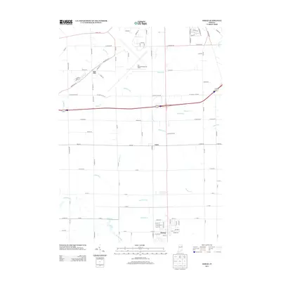
2013 Map of Ossian
USGS Topo · Published 2013About this map
Fort Wayne International Airport dominates the northern landscape of this region, serving as a modern anchor for a territory defined by intricate water management. The southern end of the airport grounds transitions into a series of agricultural and drainage networks, where Robinson Creek and numerous man-made channels like Brindle Ditch and Harber Ditch dictate the flow of the land. The town of Ossian sits at the southern edge of the survey, connected to the northern hubs via the Airport Expy and local corridors like Indianapolis Rd. Small crossroads like Yoder and Nine Mile appear along these routes, illustrating the gradual expansion of suburban and industrial influence into formerly rural Allen County. The presence of features such as Moser Lake and Eightmile Cr underscores the low-lying nature of the terrain, which has necessitated an extensive system of named ditches, including Allen Mellot Ditch and Johnson Ditch, to support local development.
Find a feature on this map
99 named features on this map. Tap any name to fly to it.
Don’t see what you’re looking for? This feature index may not catch every label — zoom into the map to look around manually.
Map Details
Editions of this 2013 Ossian Map
This is the sole edition of this map. No revisions or reprints were ever made.
Other maps of this area

1953 · Fort Wayne
USGS Topo · 1:250,000

1953 · Muncie
USGS Topo · 1:250,000

1955 · Markle
USGS Topo · 1:24,000

1956 · Muncie
USGS Topo · 1:250,000

1956 · Fort Wayne
USGS Topo · 1:250,000

1956 · Fort Wayne West
USGS Topo · 1:24,000

1956 · Fort Wayne East
USGS Topo · 1:24,000

1961 · Arcola
USGS Topo · 1:24,000
1961 · Zanesville
USGS Topo · 1:24,000

1962 · Poe
USGS Topo · 1:24,000