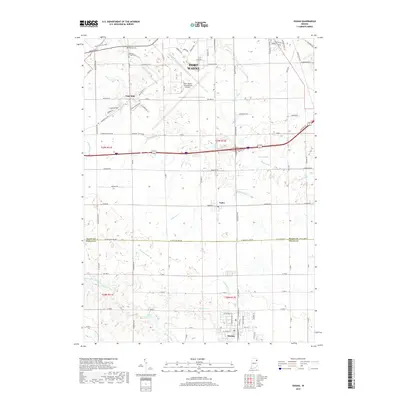
2019 Map of Ossian
USGS Topo · Published 2019About this map
The town of Ossian anchors the southern boundary of this Allen and Wells County landscape, where rural agricultural patterns meet the expanding southern reach of Fort Wayne. Near the northern edge, the Fort Wayne International Airport occupies a significant footprint, surrounded by a transition from industrial zones like International Blvd to the preserved woodland of Fogwell Forest Trails. Historically, this area is defined by a dense network of water management features, including Eightmile Creek, Thiele Ditch, and Johnson Ditch, which underscore the region's heritage of transforming wetland into productive farmland.
Find a feature on this map
89 named features on this map. Tap any name to fly to it.
Don’t see what you’re looking for? This feature index may not catch every label — zoom into the map to look around manually.
Map Details
Editions of this 2019 Ossian Map
This is the sole edition of this map. No revisions or reprints were ever made.
Other maps of this area

1953 · Fort Wayne
USGS Topo · 1:250,000

1953 · Muncie
USGS Topo · 1:250,000

1955 · Markle
USGS Topo · 1:24,000

1956 · Muncie
USGS Topo · 1:250,000

1956 · Fort Wayne
USGS Topo · 1:250,000

1956 · Fort Wayne West
USGS Topo · 1:24,000

1956 · Fort Wayne East
USGS Topo · 1:24,000

1961 · Arcola
USGS Topo · 1:24,000
1961 · Zanesville
USGS Topo · 1:24,000

1962 · Poe
USGS Topo · 1:24,000