
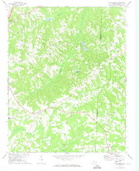
1970 Map of Ossipee
USGS Topo · Published 1973About this map
The Haw River carves a winding path through the borderlands of Alamance, Guilford, and Rockingham Counties, serving as the central geographic feature for the small communities of Ossipee and Altamahaw. At the start of the 1970s, this landscape was defined by its network of rural congregations and family-associated landmarks, such as Apples Chapel Cem and Brown Wesleyan Ch. The presence of the Altamahaw-Ossipee Sch and the Water Tank in Ossipee reflects a concentrated settlement pattern along the river's eastern banks, contrasting with the more dispersed homesteads near Osceola to the northwest.
Find a feature on this map
26 named features on this map. Tap any name to fly to it.
Don’t see what you’re looking for? This feature index may not catch every label — zoom into the map to look around manually.
Map Details
Editions of this 1970 Ossipee Map
This is the sole edition of this map. No revisions or reprints were ever made.
Other maps of this area

1951 · Browns Summit
USGS Topo · 1:24,000

1952 · Mc Leansville
USGS Topo · 1:24,000

1953 · Greensboro
USGS Topo · 1:250,000

1954 · Greensboro
USGS Topo · 1:250,000

1962 · Greensboro
USGS Topo · 1:250,000

1966 · Greensboro
USGS Topo · 1:250,000

1969 · Burlington
USGS Topo · 1:24,000

1969 · Lake Burlington
USGS Topo · 1:24,000

1970 · Gibsonville
USGS Topo · 1:24,000
1972 · Williamsburg
USGS Topo · 1:24,000