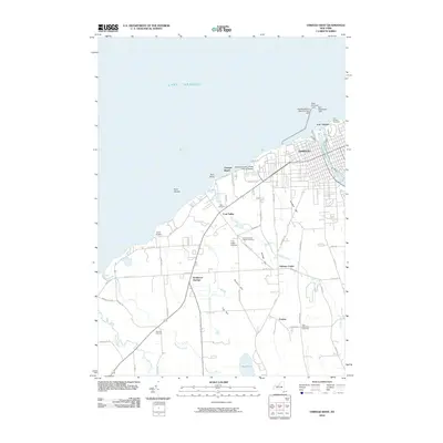
2010 Map of Oswego West
USGS Topo · Published 2010About this map
Fort Ontario stands prominently at the mouth of the Oswego River, marking a deep intersection of military and maritime history on the shores of Lake Ontario. This coastal landscape is defined by the strategic infrastructure of Oswego, where the Oswego Canal meets the lake alongside essential navigational aids like the West Pierhead Light and East Breakwater Light. The terrain rises from the shoreline through several named elevations such as Gardner Hill and Bunker Hill, transitioning from the urban harbor to rural agricultural operations like the Fruit Valley Orchard.
Find a feature on this map
65 named features on this map. Tap any name to fly to it.
Don’t see what you’re looking for? This feature index may not catch every label — zoom into the map to look around manually.
Map Details
Editions of this 2010 Oswego West Map
This is the sole edition of this map. No revisions or reprints were ever made.
Other maps of this area

1900 · Oswego
USGS Topo · 1:62,500

1900 · Fulton
USGS Topo · 1:62,500

1943 · Oswego East
USGS Topo · 1:31,680

1943 · Oswego West
USGS Topo · 1:31,680

1943 · Hannibal
USGS Topo · 1:31,680

1943 · West Of Texas
USGS Topo · 1:31,680

1943 · Fair Haven
USGS Topo · 1:31,680
1943 · West Ninemile Point
USGS Topo · 1:31,680
1943 · Fulton
USGS Topo · 1:31,680
1954 · Hannibal
USGS Topo · 1:24,000