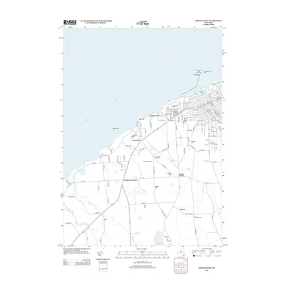
2013 Map of Oswego West
USGS Topo · Published 2013About this map
Lake Ontario defines the northern edge of this coastal landscape, where the Oswego River meets the harbor. The lakeside area is anchored by Suny Coll At Oswego and the Oswego Harbor West Pierhead Light, marking the vital maritime entry to the city. Moving inland, the terrain rises toward localized high points like Tug Hill and Bunker Hill, with numerous small watercourses such as Rice Cr and Snake Cr draining toward the Great Lake. Rural life is evidenced by the distribution of several family and community burial grounds, including the Irish Settlement Cem and Union Village Rural Cem. Smaller settlements such as Fruit Valley and Furniss are connected by a grid of local roads, while the Fruit Valley Orchard and Camp Hollis reflect the area's agricultural and recreational character in the early 21st century.
Find a feature on this map
133 named features on this map. Tap any name to fly to it.
Don’t see what you’re looking for? This feature index may not catch every label — zoom into the map to look around manually.
Map Details
Editions of this 2013 Oswego West Map
This is the sole edition of this map. No revisions or reprints were ever made.
Other maps of this area

1900 · Oswego
USGS Topo · 1:62,500

1900 · Fulton
USGS Topo · 1:62,500

1943 · Oswego East
USGS Topo · 1:31,680

1943 · Oswego West
USGS Topo · 1:31,680

1943 · Hannibal
USGS Topo · 1:31,680

1943 · West Of Texas
USGS Topo · 1:31,680

1943 · Fair Haven
USGS Topo · 1:31,680
1943 · West Ninemile Point
USGS Topo · 1:31,680
1943 · Fulton
USGS Topo · 1:31,680
1954 · Hannibal
USGS Topo · 1:24,000