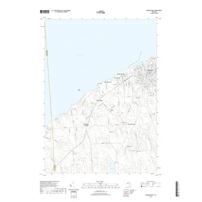
2019 Map of Oswego West
USGS Topo · Published 2019About this map
The western edges of Oswego and the lakeside campus of SUNY Oswego define the shoreline of Lake Ontario in this contemporary survey. Along the riverfront, the Oswego County Courthouse and the nearby Fort Ontario Post Cem anchor the historic street grid of the city's west side. Further inland, the landscape transitions to the rolling hills and creek valleys of rural Oswego County, where small crossroads settlements such as Fruit Valley, Southwest Oswego, and Furniss remain identifiable markers of the regional community.
Find a feature on this map
118 named features on this map. Tap any name to fly to it.
Don’t see what you’re looking for? This feature index may not catch every label — zoom into the map to look around manually.
Map Details
Editions of this 2019 Oswego West Map
This is the sole edition of this map. No revisions or reprints were ever made.
Other maps of this area

1900 · Oswego
USGS Topo · 1:62,500

1900 · Fulton
USGS Topo · 1:62,500

1943 · Oswego East
USGS Topo · 1:31,680

1943 · Oswego West
USGS Topo · 1:31,680

1943 · Hannibal
USGS Topo · 1:31,680

1943 · West Of Texas
USGS Topo · 1:31,680

1943 · Fair Haven
USGS Topo · 1:31,680
1943 · West Ninemile Point
USGS Topo · 1:31,680
1943 · Fulton
USGS Topo · 1:31,680
1954 · Hannibal
USGS Topo · 1:24,000