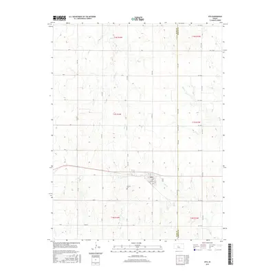
2015 Map of Otis
USGS Topo · Published 2015About this map
Otis serves as the primary hub in this High Plains landscape, situated along a straight east-west transit corridor defined by Ave L. The town's grid is compact, transitioning quickly into a sprawling agricultural checkerboard partitioned by a systematic network of section-line roads, including NW 140 Rd and Ave G. This 2015 survey reveals how the local topography is shaped by the subtle drainage of prairie waterways, with Eagle Cr, Blood Cr, and Boot Cr carving shallow valleys through the terrain. A notable cultural landmark is the Lutheran Cem, located south of the main settlement. The map also delineates the jurisdictional boundary between Rush Co and Barton Co on the eastern edge, capturing the enduring rural structure of this central Kansas region.
Find a feature on this map
30 named features on this map. Tap any name to fly to it.
Don’t see what you’re looking for? This feature index may not catch every label — zoom into the map to look around manually.
Map Details
Editions of this 2015 Otis Map
This is the sole edition of this map. No revisions or reprints were ever made.
Other maps of this area

1889 · Larned
USGS Topo · 1:125,000

1891 · Great Bend
USGS Topo · 1:125,000

1891 · Larned
USGS Topo · 1:125,000

1893 · Great Bend
USGS Topo · 1:125,000

1896 · Russell
USGS Topo · 1:125,000

1896 · Hays
USGS Topo · 1:125,000

1955 · Great Bend
USGS Topo · 1:250,000

1957 · Great Bend
USGS Topo · 1:250,000

1958 · Great Bend
USGS Topo · 1:250,000
1960 · Heizer
USGS Topo · 1:24,000