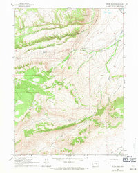
1960 Map of Otter Creek
USGS Topo · Published 1971About this map
Muddy Mountain dominates this portion of the Wyoming landscape, where the high-altitude terrain is defined by ranching life and a complex network of seasonal drainages. Established ranch sites like the Milne Ranch, Harris Ranch, and Brooks Ranch are positioned along the lower elevations where water is accessible from streams such as Muddy Creek and Smith Creek. The inclusion of a Cow Camp in the northeastern quadrant suggests the area's primary use for cattle grazing during the summer months. To manage water in this arid environment, early 20th-century irrigation efforts are evident in the Silver State Ditch No 1 and Lone Bear Ditch No 2. Further south, the map captures the headwaters of Otter Creek and the beginnings of Deer Creek Park, showing a transition from the prominent Hogback ridge toward the high plateau country.
Find a feature on this map
24 named features on this map. Tap any name to fly to it.
Don’t see what you’re looking for? This feature index may not catch every label — zoom into the map to look around manually.
Map Details
Editions of this 1960 Otter Creek Map
2 editions found
Other maps of this area

1949 · Brookhurst
USGS Topo · 1:24,000

1950 · Lockett
USGS Topo · 1:24,000

1950 · Brookhurst
USGS Topo · 1:24,000

1951 · Casper
USGS Topo · 1:24,000

1955 · Casper
USGS Topo · 1:250,000

1958 · Casper
USGS Topo · 1:250,000

1960 · Crimson Dawn
USGS Topo · 1:24,000

1960 · Sheep Creek
USGS Topo · 1:24,000

1960 · Ice Cave Mountain
USGS Topo · 1:24,000

1960 · Banner Mtn
USGS Topo · 1:24,000