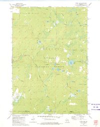
1972 Map of Otter Lake
USGS Topo · Published 1975About this map
Nicolet National Forest encompasses the vast majority of this 1970s landscape, where a complex network of glacial lakes and waterways defines the Northwoods terrain. The North Branch Oconto River and Rat River cut through a dense topography of wetlands and springs, such as Johnson Spring and Camp 1 Springs. While human settlement is sparse, the map documents early infrastructure through named timber and transport routes like Kufner Road and Mexico Road. These roads provide access to specific water bodies like Otter Lake and Indian Lake, reflecting the area's development for recreation and resource management. The intersection of Forest and Oconto counties near Bluegill Lake illustrates the political boundaries superimposed over this water-rich environment, where even small features like the Sewage Disposal Ponds and various Gravel Pits mark the footprint of local utility and road maintenance.
Find a feature on this map
36 named features on this map. Tap any name to fly to it.
Don’t see what you’re looking for? This feature index may not catch every label — zoom into the map to look around manually.
Map Details
Editions of this 1972 Otter Lake Map
This is the sole edition of this map. No revisions or reprints were ever made.
Other maps of this area

1939 · Goodman
USGS Topo · 1:48,000

1939 · Laona
USGS Topo · 1:48,000

1940 · Thunder Mtn.
USGS Topo · 1:48,000

1942 · Wabeno
USGS Topo · 1:48,000

1946 · Laona
USGS Topo · 1:48,000

1946 · Goodman
USGS Topo · 1:48,000

1950 · Wabeno
USGS Topo · 1:48,000

1951 · Wabeno
USGS Topo · 1:48,000

1951 · Thunder Mountain
USGS Topo · 1:48,000

1954 · Iron Mountain
USGS Topo · 1:250,000