
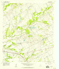
1957 Map of Otto
USGS Topo · Published 1958About this map
Otto stands as a central settlement in this late 1950s agricultural landscape, situated where the Missouri Pacific railroad cuts through the heart of the Texas Blackland Prairies. The map reveals a community defined by its creeks and small-town infrastructure, including St Johns Ch and Criswell Ch. The area is notably shaped by the drainage patterns of Big Pacific Creek and Little Brushy Creek, which meander through a series of farms and rural properties.
Find a feature on this map
25 named features on this map. Tap any name to fly to it.
Don’t see what you’re looking for? This feature index may not catch every label — zoom into the map to look around manually.
Map Details
Editions of this 1957 Otto Map
This is the sole edition of this map. No revisions or reprints were ever made.
Other maps of this area

1920 · Mart
USGS Topo · 1:62,500

1954 · Waco
USGS Topo · 1:250,000

1955 · Waco
USGS Topo · 1:250,000

1956 · Mart
USGS Topo · 1:24,000

1957 · Groesbeck
USGS Topo · 1:62,500

1957 · McClanahan
USGS Topo · 1:24,000

1957 · Riesel
USGS Topo · 1:24,000

1957 · Marlin
USGS Topo · 1:24,000
1957 · Elk
USGS Topo · 1:24,000

1965 · Kosse West
USGS Topo · 1:24,000