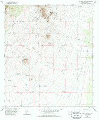
1958 Map of Outlaw Mountain
USGS Topo · Published 1985About this map
Gleeson stands at the northern edge of this Cochise County landscape, where the mining history of the Mule Mountains meets the expansive Sulphur Springs Valley. Surveyed in the late 1950s, the terrain is marked by remnants of earlier extraction efforts, including numerous Shafts and Tunnels near Maud Hill. An Old Railroad Grade winds through the hills, tracing the transport corridor that once served these remote camps.
Find a feature on this map
35 named features on this map. Tap any name to fly to it.
Don’t see what you’re looking for? This feature index may not catch every label — zoom into the map to look around manually.
Map Details
Editions of this 1958 Outlaw Mountain Map
3 editions found
Other maps of this area

1916 · Pearce
USGS Topo · 1:125,000

1922 · Swisshelm
USGS Topo · 1:62,500

1925 · Gleeson
USGS Topo · 1:62,500

1926 · Light
USGS Topo · 1:62,500

1926 · Courtland
USGS Topo · 1:62,500

1955 · Douglas
USGS Topo · 1:250,000
1957 · Hay Mountain
USGS Topo · 1:24,000

1958 · Squaretop Hills
USGS Topo · 1:62,500

1958 · Swisshelm Mtn
USGS Topo · 1:62,500

1958 · Pearce
USGS Topo · 1:62,500