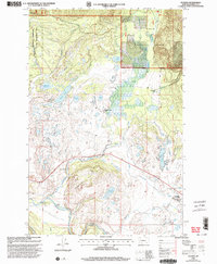
1999 Map of Ovando
USGS Topo · Published 2003About this map
The Ovando townsite serves as the southern anchor of this Powell County landscape, where the Blackfoot River flows through the southern valley floor. This 1990s revision of earlier surveys shows a region defined by the intersection of working ranchlands and protected wilderness. The drainage of Monture Creek and Dick Creek feeds into a network of small lakes and reservoirs, including Upsata Lake and Lahrity Lake. Significant land management boundaries are visible, with the Lolo National Forest and the Blackfoot Clearwater Wildlife Management Area occupying large portions of the terrain. Local landmarks such as the Scotty Brown Bridge and the Monture Hereford Ranch provide concrete points of reference for genealogists and researchers tracking the settlement history of this Montana valley. The transition from the Little Red Hills to the river corridor highlights the distinct geography that supported the area's grazing and timber heritage.
Find a feature on this map
33 named features on this map. Tap any name to fly to it.
Don’t see what you’re looking for? This feature index may not catch every label — zoom into the map to look around manually.
Map Details
Editions of this 1999 Ovando Map
This is the sole edition of this map. No revisions or reprints were ever made.
Other maps of this area

1902 · Ovando
USGS Topo · 1:125,000

1905 · Ovando
USGS Topo · 1:125,000

1919 · Drummond
USGS Topo · 1:125,000

1921 · Drummond
USGS Topo · 1:125,000

1947 · Butte
USGS Topo · 1:250,000

1955 · Choteau
USGS Topo · 1:250,000

1957 · Choteau
USGS Topo · 1:250,000

1958 · Butte
USGS Topo · 1:250,000

1958 · Choteau
USGS Topo · 1:250,000

1960 · Butte
USGS Topo · 1:250,000