1958 Map of Overton
USGS Topo · Published 1980About this map
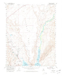
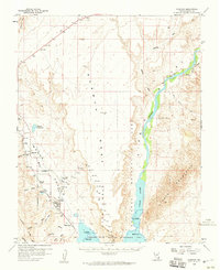
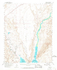
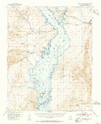
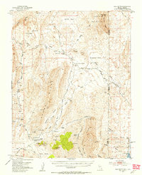
Logandale and Overton stand as the primary hubs of the Moapa Valley during this 1950s survey, positioned along the banks of the Muddy River and the tracks of the Union Pacific railroad. To the east, the landscape is defined by the massive Mormon Mesa and the wide, braided course of the Virgin River as it flows toward Lake Mead. The map captures a moment when the northern reaches of the Lake Mead National Recreation Area were being defined, including the Overton State Wildlife Management Area. Notable smaller settlements and locations like Amber, Glassand, and the Overton Museum provide specific points of interest for local history. The presence of the Overton Airport and the Radio Fan Beacon reflect mid-century infrastructure in this desert region, while the southern shoreline shows the encroaching waters of the reservoir near Kaolin.
Find a feature on this map
27 named features on this map. Tap any name to fly to it.
Don’t see what you’re looking for? This feature index may not catch every label — zoom into the map to look around manually.
Map Details
Editions of this 1958 Overton Map
3 editions found
Other maps of this area

1886 · Saint Thomas
USGS Topo · 1:250,000

1893 · Saint Thomas
USGS Topo · 1:250,000

1926 · Bonelli
USGS Topo · 1:96,000

1926 · Boulder Canyon
USGS Topo · 1:96,000

1953 · Muddy Peak
USGS Topo · 1:62,500
1953 · Overton Beach
USGS Topo · 1:62,500
1953 · Gold Butte
USGS Topo · 1:62,500

1954 · Las Vegas
USGS Topo · 1:250,000

1957 · Las Vegas
USGS Topo · 1:250,000
1957 · Mesquite
USGS Topo · 1:62,500