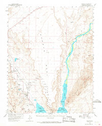
1958 Map of Overton
USGS Topo · Published 1968About this map
Logandale and Overton anchor the Moapa Valley in this 1950s survey, showing the agricultural and transport corridor just north of the rising waters of Lake Mead. The Union Pacific railroad tracks and the Muddy River dictate the settlement pattern, connecting the small communities of Glassand and Kaolin through the valley floor. Cultural landmarks like the Overton Museum and Overton Airport appear alongside local cemeteries, providing key points for genealogical research.
Find a feature on this map
33 named features on this map. Tap any name to fly to it.
Don’t see what you’re looking for? This feature index may not catch every label — zoom into the map to look around manually.
Map Details
Editions of this 1958 Overton Map
3 editions found

Other maps of this area

1886 · Saint Thomas
USGS Topo · 1:250,000

1893 · Saint Thomas
USGS Topo · 1:250,000

1926 · Bonelli
USGS Topo · 1:96,000

1926 · Boulder Canyon
USGS Topo · 1:96,000

1953 · Muddy Peak
USGS Topo · 1:62,500

1953 · Overton Beach
USGS Topo · 1:62,500

1953 · Gold Butte
USGS Topo · 1:62,500

1954 · Las Vegas
USGS Topo · 1:250,000

1957 · Las Vegas
USGS Topo · 1:250,000

1957 · Mesquite
USGS Topo · 1:62,500