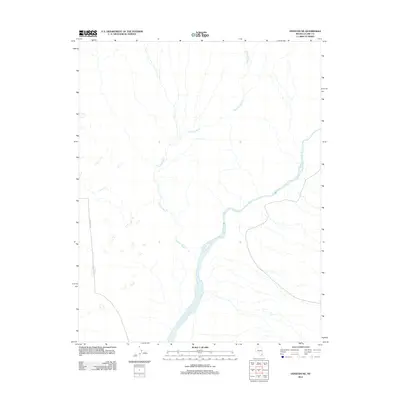
2012 Map of Overton NE
USGS Topo · Published 2012About this map
The Virgin River carves a dominant path through this corner of Clark County, defining the drainage patterns and topography of the eastern Mojave landscape. The river corridor is the primary geographical anchor in an area otherwise characterized by ephemeral waterways and desert trackways. To the north and west, the long course of Halfway Wash feeds toward the river, illustrating the complex system of dry washes that transform during seasonal rains. Human presence is sparse, marked primarily by the remote path of Carp Elgin Rd as it skirts the western edge of the quadrangle. The map reveals the natural desert hydrology before it reaches the larger reservoirs of the region, providing a clear view of the river's original braided channel and the surrounding alluvial plains.
Find a feature on this map
3 named features on this map. Tap any name to fly to it.
Don’t see what you’re looking for? This feature index may not catch every label — zoom into the map to look around manually.
Map Details
Editions of this 2012 Overton NE Map
This is the sole edition of this map. No revisions or reprints were ever made.
Other maps of this area
1886 · Saint Thomas
USGS Topo · 1:250,000
1893 · Saint Thomas
USGS Topo · 1:250,000
1954 · Las Vegas
USGS Topo · 1:250,000
1957 · Las Vegas
USGS Topo · 1:250,000
1957 · Mesquite
USGS Topo · 1:62,500
1958 · Virgin Peak
USGS Topo · 1:62,500
1958 · Overton
USGS Topo · 1:62,500
1959 · Las Vegas
USGS Topo · 1:250,000
1962 · Las Vegas
USGS Topo · 1:250,000
1969 · Moapa Peak
USGS Topo · 1:24,000